This website requires JavaScript.
Interactive Atlas

Mapping Hybrid Threats Attributed to Russia in Europe

Summary

As part of its strategic intelligence missions, CASSINI has built over the years an extensive database on the international activities of the Wagner Group — and its successor entities — as well as on various hybrid actions attributed to or strongly suspected of being linked to Russia in Europe.

In order to transform this open-source data into a tool for strategic understanding, CASSINI deployed its Atlas platform to offer an interactive map enabling users to explore, filter, and structure this information on a global scale.

Problem Statement

The activities of the Wagner Group and, more broadly, certain hybrid actions attributed to Russia (cyberattacks, sabotage, drone overflights, influence operations) are often analysed in a fragmented manner. Taken in isolation, these actions appear as distinct events that are difficult to connect to one another.

The challenge was to move beyond this fragmented reading in order to highlight the strategic coherence of a system: the data indeed reveals a consistent pattern of territorial implantation, a broad diversification of operational methods, and a strong articulation between formal actors and parallel networks.

The goal was therefore to transform a scattered database into a structured and intelligible geopolitical reading.

Deployed Solution

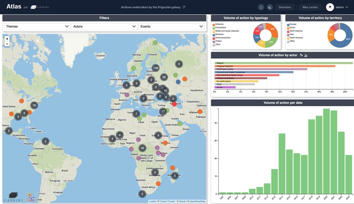
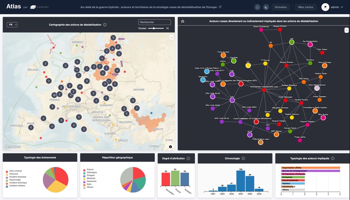
The CASSINI team first undertook the task of identifying, geolocating, and classifying events that occurred in Europe (espionage, technical incidents, criminal acts, influence operations…) and attributed to Russia, using OSINT investigation techniques and information monitoring. In this way, we built a georeferenced database of more than 300 events for each project (hybrid threats in Europe and the Wagner Galaxy), classified by date of occurrence, nature, degree of attribution, and the Russian actors involved.

Atlas then made it possible to map all the recorded events by linking them to territories, time periods, action typologies, and associated actors. Our interactive interfaces offer the ability to filter data according to several criteria: geographic areas, years, types of operations (military, informational, economic, cyber), and implicated or suspected structures.

This system makes it possible to visualise in just a few clicks the spatial and temporal evolution of activities, to identify geographic concentrations, projection patterns, or escalation sequences.

Link to the interactive map: Prigozhin Chronology / Wagner Galaxy

In the case of hybrid actions in Europe, the dataset makes it possible to map a galaxy of actors involved. Our dashboard structures the data around key indicators and puts into perspective the interactions between actors and territories.

Links to the interactive map: Russian Destabilization Strategy in Europe

Strategic Impact

The interactive map considerably enhances the readability of these complex phenomena. By linking actions dispersed across space and time, Atlas reveals coherent dynamics and allows users to grasp the existence of a global strategy rather than a succession of isolated incidents.

The tool offers researchers, journalists, public decision-makers, and private actors a clear, accessible, and exploratory strategic vision. It transforms a dense documentary corpus into a pedagogical and analytical instrument of high added value.

Beyond this specific case, this project demonstrates Atlas's capacity to structure sensitive or complex databases, to frame information analytically, and to offer an immediately actionable strategic reading.

Étude de cas précédente

Anticipating Geopolitical Risks Affecting Maritime Routes in the Red Sea
Strategic foresight
Anticipating Geopolitical Risks Affecting Maritime Routes in the Red Sea
Following the attacks of 7 October 2023 and the extension of the conflict in the Middle East, a major maritime shipping operator engaged CASSINI to anticipate the evolution of tensions in the Red Sea and their consequences for its operations.

Étude de cas suivante

Prospective map of the Lake Chad region — geopolitical and climate scenarios for 2050 (Chad, Niger, Nigeria, Cameroon)
Strategic foresight
Geopolitical Scenarios around Lake Chad by 2050
As part of the preparation for a Conference of the Parties (COP), WWF commissioned CASSINI to conduct a prospective exercise on the geopolitical evolution of the Lake Chad region by 2050, based on four possible climate trajectories.